PHOTO
NSW Government Fisheries Officers have been kept busy across the Riverina following the opening of the Murray Crayfish season last month.
Officers undertook inland patrols focusing on compliance with fishing regulations, conducting 119 campsite inspections involving about 393 fishers.
High-visibility patrols covered the Murrumbidgee River from Gundagai to Berembed Weir near Narrandera.
Most fishers were adhering to the rules, however there were 46 fishers who were reported for offences.
These included possessing Murray Crayfish outside the legal size limits, possessing Murray Crayfish carrying external eggs (ova), and taking or attempting to take Murray Crayfish from prohibited waters.
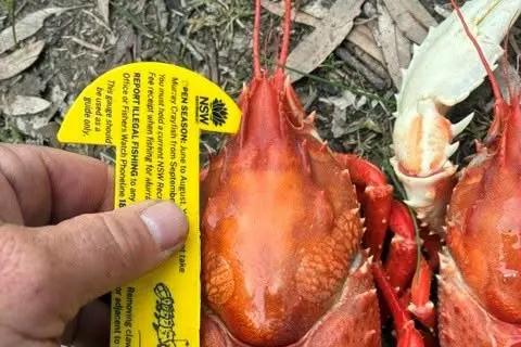
Fisheries Officers have sent out a reminder that accurate measuring is essential, warning that “close enough is not good enough” when checking the size of the catch.
Murray Crayfish must be measured from the rear of the eye socket to the centre rear of the carapace (main body shell) and must be no smaller than 10cm or greater than 12cm in carapace length.
Bag limits also remain in place, with fishers permitted to take only two Murray Crayfish per person each day from specified waters, with a maximum possession limit of four.
Fishers are encouraged to download the FishSmart app for the latest information on fishing rules, size and bag limits and fishing closures.
Anyone who witnesses illegal fishing activity is urged to contact Fishers Watch on 1800 043 536 to help protect the state’s fisheries resources.
Meanwhile, the NSW Government Fisheries Aquatic Habitat Mapping Team has completed another round of habitat mapping.
The team recorded fishy features along the lower Murrumbidgee River, on behalf of the Riverina Local Land Services, documenting important aquatic habitat features to help improve conditions for native fish.
During the survey, officers recorded in-channel features both above and below the waterline, riparian vegetation and potential threats to native fish habitat.
The latest work builds on habitat mapping completed in 2023 between Wagga and Hay, providing a more comprehensive picture of the river system.
The information collected will assist land managers in identifying river reaches where habitat protection and rehabilitation projects will deliver the greatest benefits.
It also helps inform future flow management to improve support for native fish populations